Pilot gigs are one of the Isles of Scilly’s best-known traditions, but behind the modern sport lies a much older maritime landscape. Around the islands, gig sheds, slipways, drangs and lookout points still survive as evidence of a working world shaped by pilotage, island communications, wreck response and coastal labour. In 2024 I joined a Cornwall Archaeological Unit team led by Cathy Parkes to help record that landscape across the inhabited islands, combining 3D survey with a project website designed to make the results easy to explore and remain accessible online for as long as possible without maintenance.
The subject
The project focused on the archaeology of Scilly’s historic gig infrastructure. These were the practical places from which crews launched, stored and maintained their boats. Some survive as substantial stone-built sheds. Others are slighter traces: wall lines, slipways, revetments or tidal routes that only become fully visible in the right conditions. Taken together, they show how deeply gig rowing was woven into island life. Scilly’s surviving remains include evidence for around 90 sheds across 60 sites, with many concentrated in vulnerable coastal locations.
The challenge
These are not straightforward sites to record. Many sit on exposed shores where erosion and rising sea levels are ongoing threats. Some key features only appear clearly at very low tide. Others make proper sense only when seen as part of a wider working landscape rather than as isolated structures. At New Quay on St Mary’s, for example, the sheds, slipway and tidal route called the Lake belong to one interconnected system.
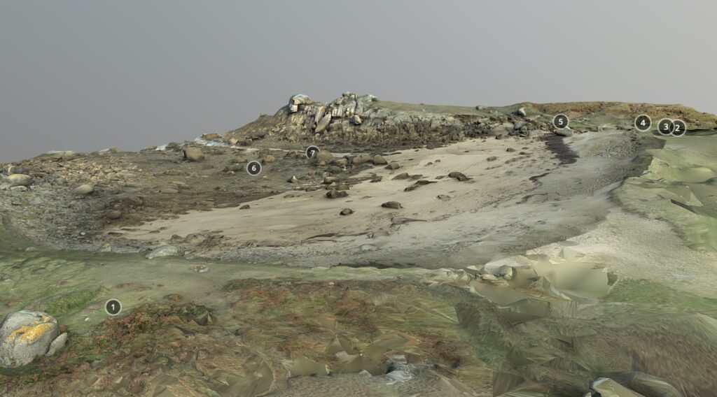
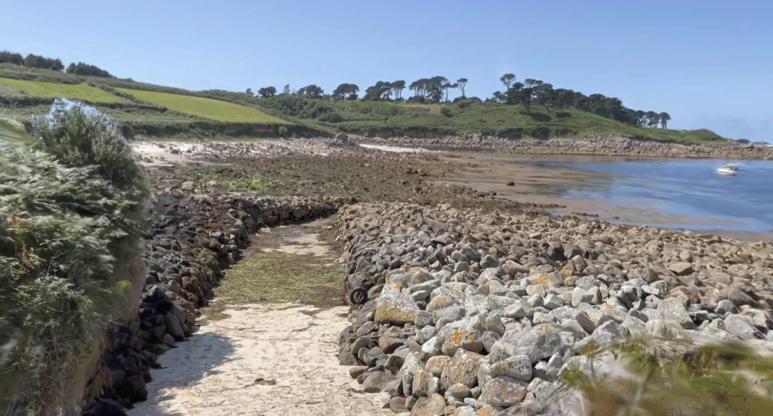
At Peraskin on St Agnes, the archaeology spreads across an outlying cove where multiple sheds and trackways survive in a place still shaped by Atlantic weather and shifting sand.
What I did
My role was to provide 3D recording and to create the project website. I travelled to all of Scilly’s inhabited islands to scan selected objects, structures and sites linked to historic gig rowing. That work sat alongside more traditional archaeological survey, including measured plans, so that the project could combine close recording with broader site interpretation.
The 3D work included photogrammetry-based models derived from site survey, processed from image data and prepared both for online viewing and for download, along with iPhone LiDAR capture for rapid ‘3D note-taking’ with centtimeric accuracy. The project repository includes OBJ versions of many models, with textures, so that the 3D evidence can be reused outside a browser as well as viewed online. Copies of the high-resolution datasets are also retained.
I also used Neural Radiance Field (NeRF) capture to record not only individual monuments but their wider settings. For Great Par on Bryher and New Quay on St Mary’s, those landscape captures were preserved in Gaussian Splatting point-cloud form as PLY files. That made it possible to show how the gig sites sit within their wider coastal topography, not just what a single structure looks like in isolation.
Alongside the fieldwork, I designed and built the project website using GitHub Pages. The idea was straightforward: keep it simple, make it robust, and avoid creating something that would need constant maintenance. The site is written in Markdown and converted to HTML through GitHub Pages, with the public repository acting as both delivery platform and archive of the project’s data. That approach means the material can be browsed conventionally as a website or directly as files and datasets. I also ensured that the project website was captured by the Internet Archive so that the information gathered by the project will remain available for as long as possible.
What became clearer
The 3D work helped make complicated sites easier to understand. At New Quay, the modelling shows how the Lake cuts through the coastal brow before turning seawards, creating a J-shaped route that helped protect the site from incoming breakers. Seen together with the sheds above it, this makes the site’s layout much easier to grasp as a working launch place rather than a scatter of separate remains. The NeRF model also helps place New Quay within its wider island setting, showing why this stretch of coast mattered for movement between St Mary’s and the off-islands. This data was used to complement a traditional plane table survey.
At Peraskin, the project captured a whole pilotage base spread across an exposed cove, where sheds, trackways and intertidal features survive in a landscape that can look deceptively empty at first glance. Elsewhere, the combination of survey and 3D recording helped preserve vulnerable remains such as the distinctive shed at Great Par on Bryher and the lookout at Beacon Hill on Tresco, where the importance of visibility and coastal command is still obvious on the ground.
Why it mattered
This project was about more than producing attractive models. It created a durable digital record of fragile coastal archaeology and made that record openly available. That matters on Scilly, where gig rowing is not just a historic subject but a living tradition with deep roots in island identity. The archaeology connects present-day rowing culture to older patterns of labour, seamanship and inter-island movement.
It also showed the value of planning for long-term access from the start. The project website was designed for longevity, with a deliberately simple structure and downloadable 3D files held alongside the interpretation. At a time when third-party platforms can change or disappear, that matters. The result is a resource that works both as public interpretation and as a practical archive for future research, reuse and heritage management.
Need 3D recording or a long-lasting website for a heritage project? Get in touch.